Map of Cambridge at Its Most Colossal
- Home
- Documented Beginnings
- Cambridge Farmers' Petition, 1682
- General Court Response, 1682
- Cambridge's Counterpetition, 1683
- General Court's Two Responses, 1683
- Survey Committee Appointment Order, 1684
- Survey Committee Report and Map, 1684
- General Court's Two Responses, 1684
- Intermission, 1684–1691
- Order Granting the Farmers’ Petition, 1691
- Cambridge Farms Parish Covenant, 1696
- Cambridge Town Records, 1712–1713
- Order Making Lexington a Town, 1713
- Cambridge on the Map
- Lexington on the Map
- Colonial Contexts
- Site Map

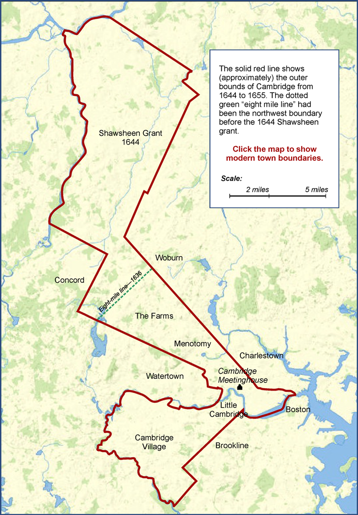
Detailed maps showing the boundaries of towns in the Massachusetts Bay Colony have not been left to us from the 1600s, and it’s even doubtful that such maps existed. Surveyors did their work capably enough back then, but what got into the records tended to be verbal formulations declaring that “the line begins at the southwest corner of Isaac Jones's farm and runs south across the meadow to a small stream near a white oak with a blaze….” This type of definition was probably sufficient at the time for most practical purposes.
The current map represents my idea of what was included in Cambridge Farms both before and after it became the town of Lexington. I got invaluable help from John C. MacLean’s excellent history of the town of Lincoln (A Rich Harvest, 1996). Since that town was put together from pieces of three older towns—Concord, Weston (originally part of Watertown), and Lexington (originally part of Cambridge)—MacLean’s research led him to study the original boundaries of all those places, and the maps he made shed light on some geographical mysteries for which I was unable to find other illumination.
Nevertheless, maps drawn more than three centuries after the fact must inevitably involve a certain amount of speculation. To whatever of this quality may underlie MacLean’s maps I have certainly added my own share. I feel fairly confident that the present map gives a good general idea of Cambridge’s 17th-century borders, but I’m also pretty sure that I must have gotten it wrong here and there.
The background of this map (including one variation with town lines and one without) comes from OLIVER, a mapping tool provided on the Web by the Massachusetts Office of Geographic Information, abbreviated MassGIS—the S is for Services. (If you’d like to investigate this, Google “MassGIS”—the URL is too long to quote here.)
The geographical features on this map are of course those of the present day, not the 17th century. Boston, for example, is no longer spoon-shaped, having gained a good deal of ground by filling in parts of the Charles River and the Harbor.
The main physical feature in the Lexington vicinity that wasn't there in the past is the large body of water seen just below the southern end of Cambridge’s eight-mile line. In 1636 it was a humble stream called Hobbs’ Brook, but it’s now the Cambridge Reservoir, created in the late 19th century by excavation and damming.
Click the map to display the version with modern town lines, and you can see that some parts of Cambridge’s wandering boundary line, now colored blue, are still doing duty. The line between Brookline and its neighbors Allston-Brighton and Newton is unchanged except that now the top end doesn't quite reach the Charles, leaving a narrow strip along the river that connects Allston and Brighton with the rest of Boston.
The straight line that runs northwest from Cambridge through the middle of Belmont originally separated it from Watertown. It is still Lexington’s boundary with Waltham (formerly part of Watertown), though the later creation of Belmont from parts of Watertown and Arlington took that part of the line out of service.
The boundary makes a 90° northward turn in Lincoln, following the “Concord line” where Cambridge abutted that town after being enlarged in 1644. Lexington’s boundary ran the same way until a triangular section of Lexington was transferred to the newer town of Lincoln in the mid-1700s. A small part of Cambridge’s old “Concord line” still separates Lexington from Bedford.
The huge Shawsheen grant that turned into Billerica now also contains most of Bedford and all of Tewksbury, not to mention small bits of Lowell and Wilmington.
The Billerica-Burlington town line has a funny little jog in it that may have been a result of the two towns’ efforts to obey the General Court's instructions. The order that made the Shawsheen grant forbade the town of Woburn (containing the future Burlington) to extend its bounds closer to the Shawsheen River than one mile. As you can see on the map (and would have expected anyway), the river doesn’t run in a straight line, and the Court’s confusing prohibition generated a fair amount of contention between Woburn and Billerica. (This was probably based less on geographic purism than on the desire of both towns to possess as much taxable property as possible.) I don’t know how the little jog in the line settled this issue, but that’s how the map was drawn in 1659. It survived several attempts to get the General Court to change it, and there it is today.
The boundary line makes its final turn back toward Cambridge at a point once called “the pine at Cambridge,” where an impressive tree marked the end of the boundary line that Cambridge and Charlestown had originally agreed on. As the map shows, the line seems to have moved in various small ways, and it may never have been followed as strictly as the towns and the surveyors intended.
Nevertheless, I do think the line as first laid out between Cambridge and Charlestown, back before Woburn was settled, was a straight one . At the northwest end, the line between Burlington and Lexington is still straight, and still in business. It can be roughly traced all the way back to the point in Cambridge where that town's boundary with Somerville begins its run toward the northwest. The creation of new towns has blotted it out in some places, and in others it seems that the line may have been altered to go around farms that accidentally straddled it. (It couldn't have been easy for incoming settlers to know the exact location of this mostly unmarked boundary.) I thought I’d be able to find surviving segments that are perfectly consistent with the Burlington-Lexington town line, but I couldn't, although some came close. Nevertheless, surviving documents make it clear that people in the 17th century thought of this long boundary as a single straight line, and that's how I drew it on the map.